How to detect and count thousands of objects within seconds ?

By Preligens, 01/27/22
The case of a Refugee camp
Refugee camps (STANAG 18-Urban areas) are sites of strategic interest for the intelligence community. Their activity provides information on the evolution of a conflict.
In order to monitor this activity, tents are the most reliable indicator to follow: intelligence professionals keep a daily track of their number, and analyze the global set up of the camp — are the latter organized in a thorough manner, are there sanitary buildings constructed nearby, is the total area covered by the tents eventually decreasing…?
But the main pain encountered in this process remains the first point: counting them.
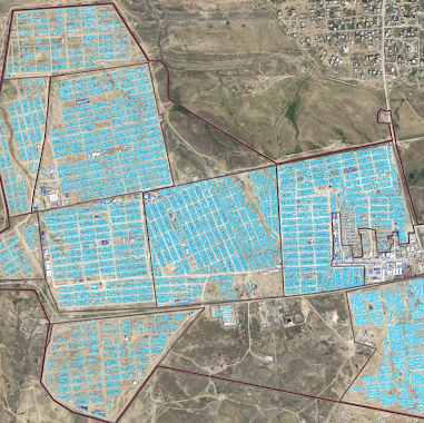
Provided that a satellite can take a picture of hundreds of square kilometers at once, and that all blue dots are tent detections, how many tents are there in the image below?

Let us save you the trouble: there are more than 16,000 blue dots in this image. 16,000+ tents that Image Interpreters count manually, representing up to a day of work, on a daily basis.
This is where AI comes into play again: it is only a matter of seconds for our tent detector to compute this result. A major gain of time for the analysts who can spend time on analyzing the global setup of the camp and the changes in the numbers over time.
In our previous use cases, we have shown many aircraft detections.
But make no mistake, tent detection represents a whole other type of technical challenge compared to aircraft detections.
There are a few reasons for that. First off, tents are very small objects when seen through the eye of an Earth Observation satellite, making it hard to differentiate them from rocks or buildings. A satellite image is a picture taken from 600 kilometers high and is thus very different from a picture taken with a smartphone.
See for yourself:

Also, monitoring tents for the sake of humanitarian or intelligence purposes is not the same as counting tents planted in the dedicated camping area of Yosemite National Park.
Refugee camps gather thousands of fortune tents. And while all tents within the same camp are alike, they change shape and aspect from one camp to another. The only way to overcome that issue, is to get as many images of as many different tents as possible, in order to make the algorithm as generic as possible.
Eventually, beyond detecting tents, and because the camp activity is a key metric to follow, another challenge comes up when the camp starts emptying: the track left on the ground by tents that have been there for a long time. Is basically looks like that:

One more difficulty that our AI team has identified alongside algorithm training, and has takled eagerly to obtain the best performing tent detector.
