The analyst’s expertise, cornerstone of the surveillance process
04/26/2021 by Preligens
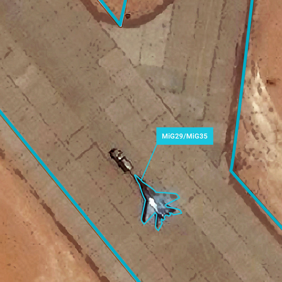
Machine Learning and AI have revolutionized strategic site surveillance by automating the most time-consuming part of the analysis: the daily, manual annotation and identification of objects within hundreds of square meters of sites of interest, hence freeing time for analysts to focus on key situations.
Yet, if automation and the results of powerful state-of-the-art object classification algorithms are impressive, one must remember that the real value is brought by the expertise of the analysts. Preligens’ solutions were developed to elevate analysts, to help them make better informed decisions, while maintaining their autonomy.
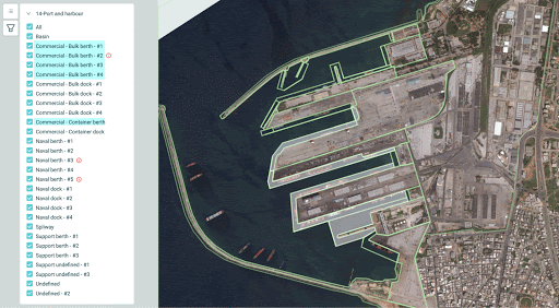
Baseline-analysis of the Tartus Port
It all starts with the Baseline-analysis: the methodology according to which sites of interest are divided into, in order to stake out the various key components of the site.
See below the military port of Tartus, Syria. It can be divided into commercial - bulk berth or dock, commercial container, naval berk, etc.
This division, that thoroughly follows NATO standards, has three goals:
- Understanding and capitalizing on information linked to a given site
- Setting up the algorithms on relevant zones and displaying the corresponding data on graphs in a comprehensive way
- Setting up a custom alert system for analysts to decide on their own monitoring rules
Indeed, once performed by the image interpreters, this breakdown of the sites of interest directly influences the results of the artificial intelligence algorithms.
Depending on the site type (airport, harbor, compound, …) different algorithms will run to detect, classify and identify objects. Any suspicious detection, since linked to a specific zone of the site, will take on a precise meaning.

Alerting and evolution of activity on the Tartus Port
But the baseline-analysis is also used to closely follow the evolution of the activity of the site, zone by zone, and to display the data in graphs for an easy understanding of the situation.
Additionally, the automated detection of abnormal changes in patterns of life thanks to artificial intelligence will raise alerts.
These alerts are not chosen at random: the analysts, relying on their expertise and their need for every given site, will choose and set up their own alert thresholds.
They then become the way for analysts to get rid of manual and daily analysis
Analysts hence have the ability to choose between alerts based on the type of object (aircraft, vessel, vehicle…) or on the sub-area of the site where they are detected.

The first type of alerts, based on the object type, is used to monitor the activity of precise types of observables. With Preligens’ classification capabilities reaching up to the variant of object (amongst 30 variants of vessels for instance), analysts can follow the evolution of the number of each entity, or the arrival or disappearing of a special kind. (e.g. the movements of the kilos submarines at Tartus port).

The second type, based on location, relies on the role each sub-area plays within a strategic site. Even at military harbors, some docks are reserved for commercial purposes. It provides insight to have warships moored there, intentionally.

Once the alert system has brought the anomaly to the attention of the analyst, the latter then gets to interpret the situation, and draw the appropriate conclusions.
Care to learn more about the application of those alerts? Watch our Tip&Cue n°2: Submarine Activity Monitoring